Where we are
Here's an interesting set of maps. After finding them, I was surprised to find that the maps were posted by the geography department of my alma mater.
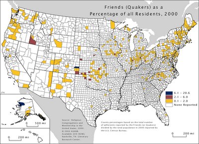
Here's one of particular interest to Friends:
I wonder about who all the Friends are in St. Louis County, Minnesota? I thought I knew both of them . . . . And what's with the Friends' strength in southwestern Idaho?
I am fascinated by the intersection of religion, culture, and politics, and love these kinds of visual comparisons, looking for patterns. One pattern I can faintly see is comparing the religious-adherents map

with the red-blue-purple political map.
![]()
Or this one, a historgram controlling for population:

3 comments:
And what's with the Friends' strength in southwestern Idaho?
I have done traveling ministry in the treasure valley of Idaho. Northwest YM has a good number of churches there,)Greenleaf, Homedale, Star,Caldwell, Boise, Merdian ?) and a school, Greenleaf academy. Many influential Quaker families farmed in that area early on - Macy, Roberts, ?. Except for Boise it is a sparesely populated area, and so the Q's would be a bigger part of the pop.
I knew someone would know.
Do you have any idea where these Friends farmers came from?
The map is based on self reporting. There is only one, small meeting in St. Louis County, MN, and the map would indicate no less than 200 self reporting as Quakers there. It may be an indication that the meeting should do some real outreach. It may be just some kind of fluke.
Post a Comment